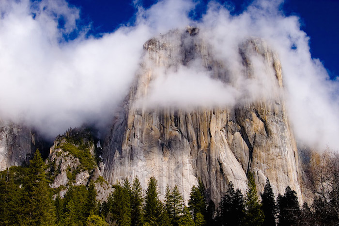
Only a small handful of elite climbers in the world have ever scaled the 3,000 foot vertical face of El Capitan, the most prestigious rock climbing destination in the United States. Call it a rite of passage in a sport where finding footholds in a smooth granite face is the only way to reach the top. It’s a sport reliant on carabiners and ropes—not exactly high tech stuff. Which is why Google’s recent launch of its street view technology on the face of El Capitan is so unexpected, giving non climbers a chance to virtually scale the beautiful granite monolith in Yosemite Valley.
So how did Google recreate its Street View feature on a 3,000 foot rock face? It’s not like a car with a camera mounted on top could just drive up the nearly vertical ascent of El Capitan. Instead, the Google Street View team solicited the help of three expert climbers, Tommy Caldwell, Lynn Hill, and Alex Honnold, who worked together to mount a tripod camera with ropes, pulleys and anchors onto the rock face at 23 different intervals along their climb. To put El Capitan’s scale in perspective, picture three Empire State Buildings stacked end to end.
No stranger to “El Cap,” as the rock face is affectionately called amongst climbers, Tommy Caldwell was one of two climbers to make history with the first successful free climb up the legendary Dawn Wall route of El Capitan this past January. Ascending 3,000 feet over 19 days, Caldwell and Jorgeson did not use ropes to help pull themselves up, but only to catch them if they fell. Of attempting a feat most called impossible, Caldwell said, “I love to dream big, and I love to find ways to be a bit of an explorer. These days it seems like everything is padded and comes with warning labels. This just lights a fire under me, and that’s a really exciting way to live.” Now anyone with an internet connection can get in on the excitement.
Getting back to the Google Street view climb: mounted by the three climbers, the camera took multiple shots from each interval, and the photos were seamlessly stitched together to create a 360 degree high definition panorama. We’ve come to know and love this seamless photo stitching technology for checking out unfamiliar neighborhoods and street views on Google maps, but instead of cars, pedestrians, and corner delis, the stunning views produced of El Capitan depict Yosemite Valley at its most stunning: sweeping views of the glacial valley from a vantage point that few have ever experienced. For a particularly challenging stretch of the climb called the Nose route, one of the climbers carried the camera equipment on his back. His pack featured a custom rig with six small cameras angled in different directions, which automatically fired every few seconds.
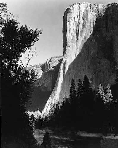
For lovers of the preserved wilderness of Yosemite Valley, this is the biggest homage to its natural beauty since Ansel Adam’s famous series of black and white photos, which he began shooting in the 1920s and continued to capture for several decades. At right is his photograph of El Capitan at sunrise, shot in 1952.
While this is the first time Google has applied its street view technology to a climbing route, they’ve been actively moving in the direction of mapping the world, off road style. They are off to an auspicious start that would make Ansel Adams proud.
Top Image: Flickr/Peter Liu Photography